 |
Ken Baldry crosses Switzerland on Foot -Col des Mosses to France. The finish. |
 |
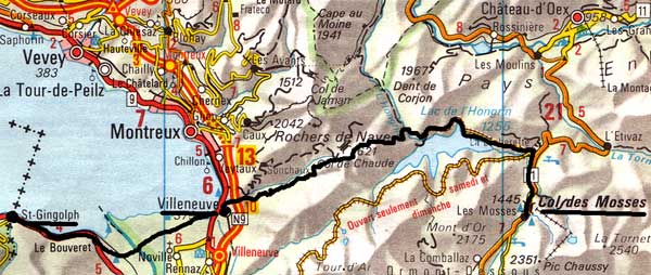 |
Route: Col des Mosses-Col de Chaud-Villeneuve-St Gingolph in FranceAnother tough day and an easy half day to finishThis map is copied from the Official Map of the Automobil-Club der Schweiz, (with their permission) which is on this link but not to scale |
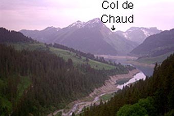
One expects them to be down at the end of the winter but every stream yesterday was in spate and many had colonised the paths as well. Before I got to the double dam, war broke out in the direction I was heading for. This was in bursts with gaps in between, presumably while the monitors analysed what the toy soldiers had achieved with their machine gun fire and mortars. I walked across the dams and found at the far side, a notice saying my way was barred for the manoevres. So, I walked back furious. I had wasted half an hour and now had to cross the Col de Chaud on KR's route, which I had intended to avoid by going down to Roche in the Rhone Valley. The road drops 160 metres from the dam into a deep gorge and then, the pass path begins, first through cow-fields and then, steeply up through the woods like yesterday, very hot making. Part way, there was a wire fence that was almost impossible to get through. I damaged it with my ice axe & a clear conscience. Above the steep part, the path slogs through woods, frequently dropping and then becomes made up by an old farmhouse before the Col. It is 1621 metres, rather than the 1480 of the Roche route, so this day was in no way a rest after yesterday. From the pass, it drops 1250 metres to Villeneuve 375m, some of which is steep path. I now have to rest going down as well as up. The water situation was getting critical but I found a chalet over a rickety bridge with signs of occupation and labelled Refuge de la Tinière (the name of the stream). No one around until I noticed them up the hillside in hammocks. This delightful old couple from Villeneuve plied me with water and questions. It made it easier to get down. I discovered at the Tourist Office that all the hotels were on the lake. The Vieux Pecheur was supposed to be reasonable but was 80 fr for a proper bath (needed). They had a café across the road on the lake and I ate there under the canvas during a storm and feeding bread to the birds. (Beefsteak, illegally out of my diet. I did not fancy experimenting with horse when so hungry). Bruckner's stormy 8th Symphony appropriately on the radio later. The day had taken 9 hours, 10 minutes.

Phew!
I hung out my thumb, getting lifts to Porte du Secx & onward to Sion and the Grande Dixence.
For another view, (Steve Rabone's) of the similar Alpine Passes Tour, follow this link
Contact: Ken Baldry, 17 Gerrard Road, Islington, London N1 8AY +44(0)20 7359 6294 or e-mail him
URL: http://www.art-science.com/Ken/Alpine/XSwiss/alpine9a.html Last revised 26/6/2008 © 1998-2008 Ken Baldry. All rights reserved.