 |
Ken Baldry crosses Switzerland on Foot -North East start - Kappl (Austria) to Laret (CH) |
 |
North East Start (September 2009)
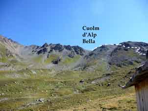
The far North-Easterly corner of Switzerland is a hill called the Grübelekopf & just next to it (West) is a pass from the Visnitztal, which comes up from Kappl in the Austrian Paznauntal. This is the Cuolm d'Alp Bella in Romansch & Visnitzjoch in German & this is the start of another way across Switzerland. Map K41 'Silvretta Verwallgruppe'
|
Monday 31st August 2009 Alpine Trip - Getting there Up at 0545 BST & walked down to St. Pancras Station in London (& a nasty sandwich) for the Eurostar TGV to Paris Gare du Nord. Then, the short walk to Gare de l'Est & the Laria TGV to Zürich & a nice tuna roll. The train to Landeck was not very full & late but a local got me a lift to the hotel off her sister - it was on their way anyway. This was lucky, as the walk would have been much longer than I had expected, 35 minutes as I found in 2011. The Hotel Bruggner Stubn was a lot posher than I had expected but the landlord had the usual difficulty reconciling my name as pronounced with his reservation list, as I had booked it over the internet. Shower, write this & crash at 2136. 7910 paces Tuesday 1st September 2009 I was up a bit too early for the adequate cold buffet breakfast but I could not cram more than three rolls down even though I only had two sandwiches yesterday effectively. The bill was €48, which seemed quite cheap for B&B, not much over £40, say. Too early for the bus, I started walking &, when I was well past the motorway junction, started thumbing, getting a lift from an old guy actually going to Kappl who did indeed drop me off at Lochau bus stop but had insisted I take the bus to Ischgl & go up the Fimbertal to the Heidelberger Hut, as a way to Samnaun & not to go over the Cuolm d'Alp Bella but not giving me a reason. There was not a cloud in the sky until late afternoon. I waited until grandpa was out of site & walked a little way up the valley |
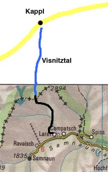
Map (not to scale) from the Official Map of the Automobil-Club der Schweiz, (with their permission) which is on this link. |
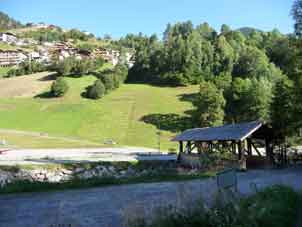
The covered bridge at Lochau - the start |
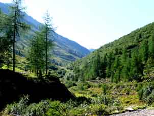
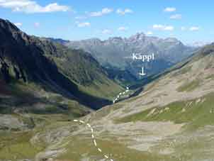
Looking up the Visnitztal |
I was overlapping an old couple but we joined up at the jeep road after the path & chatted as best we could up to Alp Visnitz, where they stopped for a beer. He was 79 but they were faster than me, so I had to work. I put up my brolly after that & worked my way up the Visnitztal gently rising until a step by the nearly-silted-up Rierersee. Then, it was steadily up past a cow hut, where I met a family of marmot hunters with a shot marmot they were going to eat. It was Mum that was carrying the wicked-looking rifle. Up a bit more to the last Zollhutte. This walk, I had already found hard work (1,200m up so far) but there are steep zig-zags for another 500m of grotty rock up to the frontier Swiss Zollhutte & it drops a bit to the actual Cuolm.
Looking back down the Visniztal from the Cuolm |
Looking up to the pass from the last cowshed |
Although the sign at Kappl (Lochau) had said Samnaun 6 hours, it had taken me 6 1/4 just to get up to Switzerland. Then down. There is a track down from the pass which is not marked even on my new Kopmass map but the waymarking, in contrast to the Austrian side, is poor. However, one can see the signpost near the Alp Bella chairlift top & head for that.
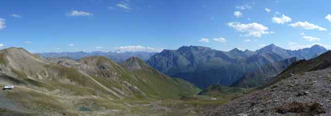
South from the Cuolm - down the valley straight ahead for Laret |
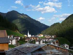
Compatsch from Laret in the evening |
After a reasonable path down, one hits the road system used to build the ski uplift for Alps Bella & Trida, about which I cannot really complain, having used them on two previous holidays but which are uncomfortable & tedious walking. Being covered in loose gravel, I did slip & get dirty at one point. Unusually, although I have to stop frequently for breath on the way 'up' anything, I found myself doing so on the way down today towards the bottom. There is a farm track which saves some road not long before Laret village, from which it is 100m at least of up to Samnaun & another hour's walking. However, the Hotel Laret beckoned, so I collapsed into it. It was sfr56 for B&B & a very nice room. It had taken me another 2 hours to get down. I did my laundry, showered & went to bed for a bit before going down for dinner which was a la carte wild pig schnitzel with spaghetti, red cabbage in abundance, chestnuts, grapes & red currents with a slice of apple. About 37.000 paces from Kappl.
Contact: Ken Baldry, 17 Gerrard Road, Islington, London N1 8AY +44(0)20 7359 6294 or e-mail him
URL: http://www.art-science.com/Ken/Alpine/XSwiss/alpine20.html Last revised 13/7/2011 © 2011 Ken Baldry. All rights reserved.