 |
Ken Baldry crosses Switzerland on Foot -Gsteig to Col des Mosses - the Blatti Pass |
 |
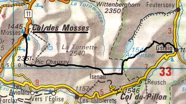 |
Route: Gsteig-Blattipass-Lac Retaud-Chersaule-Col des MossesQuite a tough day.This map is copied from the Official Map of the Automobil-Club der Schweiz, (with their permission) which is on this link but not to scale |
Monday 19th June 1995
Up at 0545 and, after getting the müsli, Avis delayed me a bit but the journey to London City Airport went very smoothly. They confiscated my ice-axe and, although the flight (Crossair 146) was on time, so I could have caught the right train, my axe had disappeared. I reported it and got the next train to Montreux. The next thing that went wrong was that the MOB train was a special with panoramic waggons and 1st Class only, so I had to pay a supplement. It was a lovely day but I don't think you can see any more from these posh coaches. However, I got to Gstaad at 1515 and bought another ice-axe for £80!, as I could see that I would really need it. It took nearly 3 hours to walk the 8-9 miles to Gsteig, partly because the path wanders away from the river and uphill a bit. I used my brolly as a parasol. The chair-lift to the Hohe Wispile was closed, so I could not use that option. Gsteig, skulking in its hole in the end of the valley, was largely shut, just as it had been 17 years before and only the relatively primitive and expensive (50 fr for a small room without facilities) Hotel Bären was open. There was a shower, though, outside my door. Good dinner. Despite the pre-tour meths treatment, my heels blistered up as usual.
Tuesday 20th June Blattipass from Gsteig 1175m to Coll des Mosses 1433m LK 263 and LK 262
Although the start has changed somewhat, owing to the making up of a path, Kev Reynolds was right that the way up to the Blatti Pass 1825m was hard work. It starts as a very steep path up through the trees but slackens later. Then, it is not clear and I went too high but realised where the snowy ridge was, reached it and moved along to the top of the pass by a rough path used by fence makers.
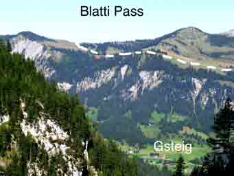
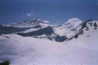
The Blatti Pass & Gsteig |
The amazing Blatti Pass view to the East |
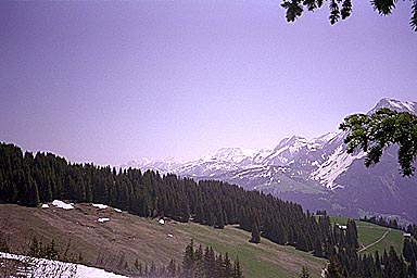
The view to the east is spectacular, all the way to the Wetterhorn. Working West are:- the Wetterhorn, Schreckhorn, Eiger, Mönch, Jungfrau, Blumlisalphorn, Frundenhorn, Altels, Doldenhorn and Wildstrubel. On the Arnensee side, it was all snow and I had to guess (correctly, as it turned out) where the path went, down to1720m. According to Kev Reynolds, one goes past the Chalet Vieux and up to the Col d'Anderets. Apart from the avalanche danger from a huge cornice, there is no point. I went across huge snowfields below the hut to what I named the Col de Chalet Vieux at 1917m and over it, joined by a French Swiss couple.
The "Col de Vieux Chalet" |
Col des Mosses at last |
The path below was very dicy as chunks had been swept off by the snow and it was difficult to get down safely, especially at one particularly icy place. It had taken six hours to get to Lac Retaud 1685m, where there was a café and I refilled my water bottle with lemonade. I had been eating snow above, digging for clean stuff and hoping I would not get tummy trouble, which I did not. (Aged 52, I should have been carrying more water). From the Lac, the path continues far above the Diablerets valley but it is not a contour path, rising towards La Marneche, dropping and rising to Meitreile 1803m, dropping to Marnex 1738m and rising to La Lé 1802m. Then it becomes jeep road and drops to Chersaule 1720m and, demoralisingly rises to Oudiou at about 1800m again. From there, it drops with only a slight rise towards Col des Mosses 1433m, where I found the Hotel du Chaussy open.
This turned out to be wonderful value. I got a good big double room with a shower room for 40 fr and a good meal. I had used double the amount of bog roll on my blisters and they were not at all bad. My usual technique is to put on an elastoplast and carefully put a wide pad of bog roll behind it, rolling my socks on so as not to displace it. This limits the damage from the continuous walking. An interesting new torture revealed itself. Now I am a fat old slob (a state corrected in 1997), my rucksack can rub my spare tyre sore and had done so. I slapped a huge elastoplast on it, which seemed to work. The walk took 10 hours, not surprising as Kev Reynolds said 8 and he did not have to contend with snow and ruined paths.
Contact: Ken Baldry, 17 Gerrard Road, Islington, London N1 8AY +44(0)20 7359 6294 or e-mail him
URL: http://www.art-science.com/Ken/Alpine/XSwiss/alpine9.html Last revised 26/5/2012 © 1998-2012 Ken Baldry. All rights reserved.