 |
Ken Baldry crosses Switzerland on Foot -Sargans to Braunwald via the Foo & Richetli Passes |
 |
Alternative to the Walensee - Sargans (or Mels) to Braunwald
Picking up from the Rhaetikon alternative, the Cross-Swiss walk would go down to the Rhine, cross it & walk drearily to Sargans & then on to Weisstannen. There would be time to walk from Steg to Weistannen in one not-too-long day. Alternately, walk from the Schesaplana Hut to Bad Ragaz, a long way down but only a half-day walk, perhaps.
|
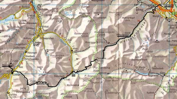
Saturday 20th July 1996 Sargans to Weisstannen LK237 I got up at 0445, had a shower & crept out without waking my wife Avis for the 1st Piccadilly Line train at 0539. There was a performance at Heathrow of wrapping up my ice axe pickel 'to prevent it piercing the 'plane's skin', otherwise no problems. There was 1.5 hours to hang about in Zürich for a train to Sargans. It was hot. This map is copied from the Official Map of the Automobil-Club der Schweiz, (with their permission) which is on this link but not to scale. |
The sign at Sargans 481m, said 3hr 45mins to Weisstannen 1004m, time which I had but it only took an unhurried but very sweaty 2hr 50mins to get there. Especially sweaty was the pull up from Mels 497m, where I crossed my original Cross Swiss Walk line. Weisstannen is a pretty spot where two valleys meet. The Hotel Gemse appeared to be the only one and was expensive at 60fr B&B (in 1996), no shower but dinner at 29fr (Saltimbocca Romana) was good.
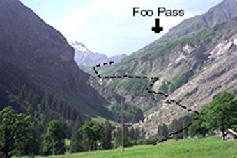
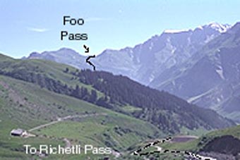
A longish valley path goes past Foo Cow Village & back, unlike the map. I stopped for mint cake just before. Then, round a knoll & up another longer valley to the col & a great view over towards tomorrow's trail. There was some variety on the path down, which still took 3 hours & ended steeply down a staircase to the valley. A short path across it to Elm village, at 977m, which is where Vreni Schneider (the Ski champion) comes from & has the (only) big sports shop & hire place for their limited skiing. Hotel Elmer offered me halb-pension for 85fr & a bathroom. I was exhausted by the heat (I had my parasol up all day) but not as badly as over the Surenen Pass. The food was good - a steak (!) after soup & before gateau for pud. I was walking in track suit rompers (although I had my proper breeches in my rucksack in case of bad weather) & washed them successfully, that is, they were nearly dry in the morning. I am also carrying an extra litre of water, all of which went.
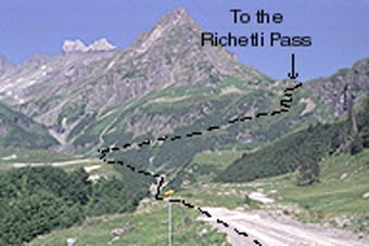
Monday 22nd July Richetli Pass from Elm to Linthal LK 247 and LK 246
 Back to the Foo Pass |
 Forward to the Richetli Pass |
Another road walk of 1.5 hours to get to 'go' but really, 'go' was at 1600m as the army have mucked up the head of the valley by digging (on-going) bunkers & roads leading to them. As I could see this from the Foo Pass yesterday, it was hardly a secret. At 1600m, a traverse path climbs to 1700 & zig-zags (the bottom one being a mess) get one up to a pleasant little gorge full of cows. I stopped for mint cake here. Then, a climb up the side to 2000m & a hut at Wicklermatt with two Swiss guys, one of whom described them as 'cow-boys' in English. Like yesterday, there was then a long top valley with a modicum of snow at the top this time & the path became very messy because of snow damage. Mostly, a very pleasant path up after 1600m. The top, 2261m has a spectacular view over the limestone country of the Klausen Pass & further north. The path down was steep & dodgy. It was unrelenting for most of 1000 metres & took 2.5 hours because of the caution exercised, exacerbated by the heat (parasol all day again) & a map-reading error which lead me to believe I had gone further than I had, which is demoralising but also lead me to finish my 2 litres of water too soon. Eventually, I staggered into the top farm & where they gave me more water. Then, there was miles of road slog. At 1650 (I had started at 0740), I heard a car & thumbed a lift for the last 4km, so I have not really done this pass but I was collapsing. I was dropped at the main road & crawled into Linthal 653m to stay at the 'simple' Hotel Raben, only 46.50fr. I dived into the bathroom, locking everyone else out of the bog on that floor for an hour, then had rubber synthetic breaded chicken (not what I expected from the menu but it was not very expensive) for dinner after soup & salad to repair my heels, now luridly blistered.
Tuesday 23rd July Linthal to Braunwald LK 246
An 'easy' day. There is a steep, 23 zig-zag path up to near Nüssbuhl from behind Linthal Station. This is not easy to find. Go up the obvious track marked to Ennetlinth for 100 yards & take the double back which is unmarked to join the track proper. Only 17 zig-zags are marked on the map. Fortunately, it is mostly in the woods but still took 1 litre of water in 2.5 sweat-soaked hours, as it was still bloody hot. At the top, I met my original Cross Swiss Walk again. I walked the path back to Braunwald 1256m, round the top of the side valley & found the path to the Bärentritt for tomorrow. This was not quite the same path as the one to the Klausen I used 2 years ago. I booked into the posh Hotel Alpenblick again & saw the Alpenblick this time but did not photo it, as it would obviously be better in the evening. Then I soaked in the bath, during which it rained & clouded up! I washed everything. The cloud shifted later & I got my photo of the Tödi eventually. I had liver & rösti for dinner after salad.
Contact: Ken Baldry, 17 Gerrard Road, Islington, London N1 8AY +44(0)20 7359 6294 or e-mail him
URL: http://www.art-science.com/Ken/Alpine/XSwiss/alpine12.html Last revised 26/6/2008 © 1998-2008 Ken Baldry. All rights reserved.