|
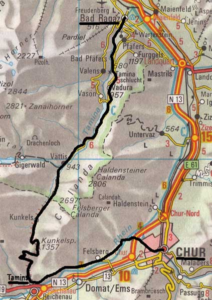
Wednesday 25th May 1994 Chur to Tamins (half-day walk) LK 247
The maps on this page are copied from the Official Map of the Automobil-Club der Schweiz, (with their permission) which is on this link but not to scale.
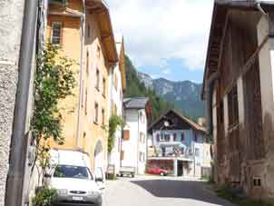
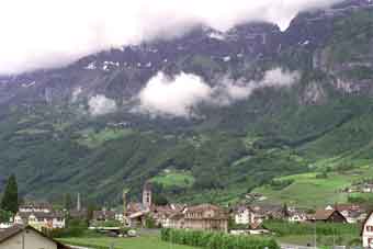
Tamins Village - note the limestone wall behind.
The sunny photos above & right were taken in 2011. The journey to Chur from London is now possible in one day by train & the return journey in 2011 was made this way.
|
I got up in plenty of time for the 0557 tube, only to find it had been cut. I had to wait another 5 minutes at Kings Cross, so, by time I got to Heathrow, I had to go straight to the gate for the 0745 to Zürich. This was not straightforward. As I had an ice-axe on my rucksack, I had to be escorted to the gate. Since 11/9/2001, you have to check in your ice-axe, so best to leave it strapped to your rucksack & put it in the hold.
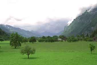
At Zürich Airport, I took a train to the HauptBahnhof and then, one to Chur 595m, where it was quite hot. Using my brolly as a parasol, I found the path by the Rhine and walked to Tamins 662m, which took 2 1/2 rather boring hours. Check at the Chur Information if there is rifle practise, as that blocks the Rhine-side path & you would have to walk out on the road towards Domat-Ems & cross to Felsberg to resume the Rhine-side walk. There was no obvious hotel in Tamins, so I asked a local and was directed to the only one. This was outrageously expensive. A single room without shower was 50fr and breakfast (the timing of which I had to argue about) was 9.40fr extra. Cheek. At least, dinner was only 14fr. (Note - 1994 prices). The proprietor had been an immigrant to South Africa (!) and had come back, as he said 'it was no place to bring up children'. However, there are hotels in Reichenau, which is down by the Rhine below Tamins, adding about a quarter-hour to what is going to be a very long walk.
From Reichenau Station
|
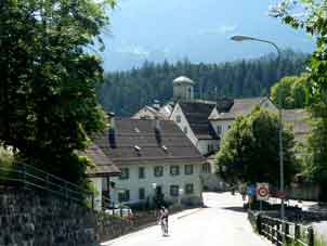
Reichenau
|
|
Thursday 26th May Tamins to Bad Ragaz over the Kunkels Pass LK 247 and LK 237
|
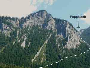
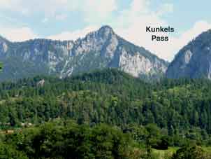
I was away by 0810, steeply up into a pretty cwm like a little Leukerbad. This was road at first. The path takes off just past the sharp, left-hand bend & doubles back east across the face of the rock wall into a strange dry hanging valley called the Foppaloch. This goes up increasingly steeply through the trees. About 3/4 the way up, it started to rain and more or less continued all day with odd breaks. At the Kunkels Pass 1357m, the path rejoins the road, which varies in condition from tarmac to jeep track (and back) all the way down. (It is possible to go on the road all the way but that commits you to a 20 mile walk, as it zig-zags a lot). I stopped for a beer at the first pub in Kunkels, which is a strung-out concept rather than a village. It was a long, pleasant walk to Vättis, then on by footpath past a partly drained reservoir. I had some lunch and, shortly after, saw a jet black knobbly little lizard or salamander.
|
|
|
This is the Tamina Tal, limestone cliffs and an obvious Valkyrie practise area. Then, the path drops and climbs back up to Valens. This was very exhausting and it was clear at Valens that the rain was falling as heavy snow above. There would be no point in staying there and trying to go to the Pizol Hut the next day, my intended route. I had more lunch and staggered down the valley in my anorak to the river bank and along to Bad Ragaz 502m. I had to stop in a wood store hut for a while to recover part way. I eventually found the Hotel Garni (but with a restaurant) Jerger in Bad Ragaz. It took 10 hours and I should have been feeling worse, considering. The Jerger, with an en-suite shower, was cheaper and better than the Crown yesterday.
|
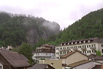
Bad Ragaz - Taminatal through the notch.
|
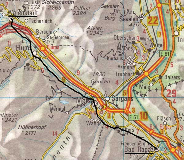 |
Friday 27th May Bad Ragaz to Walenstadt LK 237
A long walk to Walenstadt. This was mostly on footpath along, first, the Rhine Valley and then, the Seez Valley, which runs westward, implying a watershed near Mels but the ground hardly rises between the Rhine and Mels. All the water ends up in the Rhine later, anyway.
I tried the footpath from Bad Ragaz to Vilters but the farmer warned me of cow-dung and I went round the aerodrome instead. The last part was path. Then, from Vilters, one does an up and over footpath to get to Wangs and another footpath to Mels. There were intermittent views through lightish rain.
Mels offers a parting of the ways. One can either go on to Walenstadt or one can turn left in the middle of the village & go up to Weisstannen, as I did in 1996. See this link for that alternative.
Meanwhile, let's carry on to Walenstadt (town website).
|
From Mels to Flums, there is a long path by the riverside and then an irritating route past the Flums Flumroc factory (which stinks horribly) and a set of footpaths across fields to avoid the motorway, eventually ending near Walenstadt Station 425m. This is the dullest part of the Cross-Swiss Walk. 6 1/2 hours. I booked into the Hotel Post in the High Street, which is a kilometre from the lake, because, as I found out after a shower, there is a barracks between town and lake. (Kaserne was a word I happened to know - Wozzeck?).
 Seeztal towards Flums |
 Walenstadt. The lake is off to the left. |
|