 |
Ken Baldry crosses Switzerland on Foot -Engelberg to Meiringen by 2 ways over the Joch Pass |
 |
Two ways, 1993 and 2001
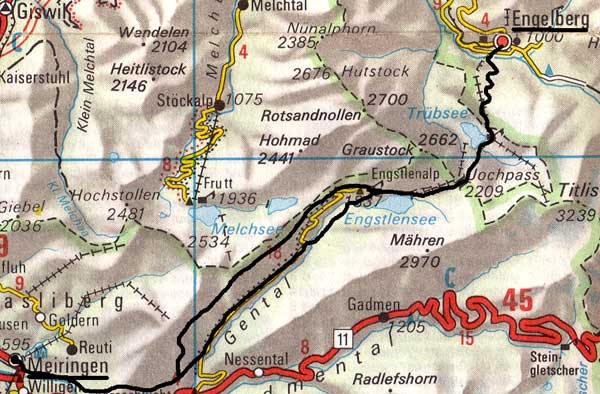 |
This map is copied from the Official Map of the Automobil-Club der Schweiz, (with their permission) which is on this link but not to scale. Thursday 7th October 1993 Walk-in a different way via Sarnen, Flüeli, Melchtal and the Jüchli Pass, which is higher & much more interesting than the Störegg. Then a rest-day walk above Engelberg. It is too far to walk from Engelberg to Meiringen in one day, so it has to be split up somehow. The first time, I did this by booking in for two nights in Engelberg, walking up to the Truebsee & down a different way, which was a lazy day after the gruelling Surenen Pass. Then, I took the gondelbahn to Truebsee & walked over from there. This is the 1993 trip below. In the 2001 High-level Path option below, I suggest splitting the walk at Engstlensee. |
Sunday 10th October 1993 Up to the Trüebsee LK245
Engelberg is at 1000m. Even sunnier than yesterday as fewer clouds. I walked up to Trüebsee 1764m by the direct path behind the Bänklialp Hotel. This is steep through the woods and then across the Gerschnialp 1257m, before winding steeply up the rock face below the gondelbahn, from which people stared at me. A very pleasant way up but I was glad I did not have a full rucksack. I idled up and down by the Bitzi Hut. The Trüebsee is bigger than the map suggests and there were some spectacular reflections in it. Tomorrow's Joch Pass route looked straight-forward. By taking the steep path down, I avoided the ubiquitous mountain bikers. From Unter Trüebsee onwards, it seemed as if half Zürich is here for the day out. I had the dreaded Riz Casimir, the Swiss half-apology for a curry for dinner.
The Trüebsee path goes up through the trees |
|
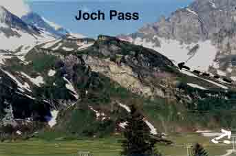
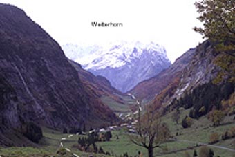
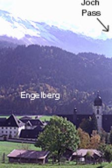
It had been a good idea to do the Trüebsee1764m bit yesterday. I went up by gondelbahn, where I met a German-speaking Korean (we had to speak German to communicate). The old Joch Pass route is discouraged, quite apart from being mostly buried in snow and I took 1 1/2 hours to get up by the path under the chair-lift. The pass is at 2209m. But it took almost 7 more hours to get to Meiringen 595m, including a half-hour stop for Käseschnitte at Schwarzental. After the snow down to Engstlenalp village, there is a pack horse track through the woods. There was a good view of the Wetterhorn (unexpected) above the Engstlensee and the Gental looked as if it was on fire because of the Autumn colouring of the trees. After lunch, there was 4 miles of road before the path turned off right into a proper narrow bergweg well above the Aareschlucht. I had trouble finding a hotel in Meiringen, as many were closed and had to pay more at the Hotel Rendezvous than I wanted, especially as it was nothing special. It was very warm during the night and a ferocious wind blew, rattling the whole building and blowing over everything in the street. It must have been the föhn, although it blew from the north past the hotel.
Tuesday 12th October 1993
Up the Aareschlucht and off to Saas Fee for more spectacular Autumn colours.
Alternative route along the side of the Gental
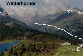
Saturday 23rd June 2001
Kev Reynolds enigmatically says that the 'higher level footpath is more attractive. Well, yes. It is also much harder. I took the gondola & chair lift to the pass &, if one was doing it as part of the complete Cross-Swiss Walk, I would advise walking all the way up from Engelberg, dropping just to Engstlensee Village & staying the night. Then, the walk down will not be too exhausting, as there is a big walk, the day after.
I turned right off the path down from the Jochpass after a few yards, onto a higher track which gives views over towards the Tannsee & the Melchsee-Frutt ski area which English people don't use. There was quite a lot of snow in large patches, including one almost blocking the start of the path. This drops down a gully to Engstlenalp village & one follows the path round near the valley wall to where a path goes up to Melchsee (snakes here).
The High-Level path. E = Engstlenalp |
The path that goes straight on looks & is, very narrow, 150-200 mm wide & stays, more or less on a dropping contour (meaning, bits of 'up' as well) to a cow village, Baumgarten, where there is no refreshment to be had, a characteristic of this trip. However, the views are broader than the valley route & one can succesively see the Wetterhorn, Schreckhorn, Lauterarrhorn & Finsteraarhorn appear. I met a herd of sheep on a narrow bit & they were not too happy about me, squashing past me nervously. Later, there was a large ramble that had started from the Hasliberg cable car from Meiringen. Eventually, the path meets a road & I went along it until there was a chalet on the right opposite a field. I went through the gate & steeply down the field, following the track to the road, which can be crossed but I carried on down the road, as the track is too steep for comfort late in the day. I turned left where the track joined (from the right) & went down to the sign for Innertkirchen. |
This track goes through the woods past the chalets at Riebgarti to an obvious track crossing with signs at Hundschipfi. The track that doubles back (effecting a huge zig-zag) to the right is the same as the valley track above & goes to Meiringen. (This sounds complicated but is clear on the map).
Contact: Ken Baldry, 17 Gerrard Road, Islington, London N1 8AY +44(0)20 7359 6294 or e-mail him
URL: http://www.art-science.com/Ken/Alpine/XSwiss/alpine5a.html Last revised 26/5/2012 © 1998-2012 Ken Baldry. All rights reserved.