 |
Ken Baldry's Alpine PagesGrüben 1822m & the Chamonix-Zermatt Walk |
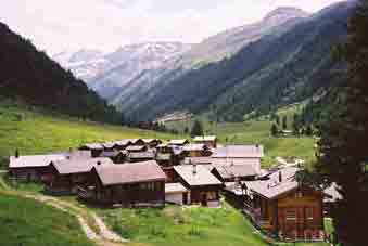
Grüben is in the Turtmanntal, a hanging valley above the South side of the Rhone Valley.
This is a remote spot, suitable for poets & writers seeking peace but is a necessary halt on the Chamonix-Zermatt Walk.
How to get there
The railway station in the Rhone Valley is Turtmann & you will probably have to change to a local train from Sierre or Visp. There is a cable car up to Oberems & a bus from there. I believe the road is now passable, as much of the village now appears to be holiday homes. Everybody like me walks in & out, as the links above imply.
When you get there...
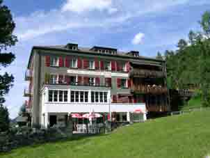
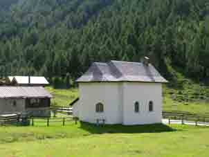
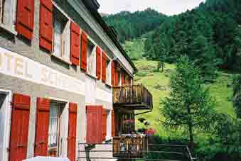
...you need somewhere to stay. That means the Hotel Schwarzhorn. This has rooms & a bunk house.
|
|
|
|
|
|
|
|
Getting into Grüben from the West
There are four options from the West for getting into Grüben, all but one covered on previous pages of the Chamonix-Zermatt Walk: two ways over Bella Tola; the Forcletta (Fugglitti) Pass & the Meid Pass. The Meid Pass from St Luc seems a bit pointless, as it is by far better to traverse Bella Tola for the fantastic view.
However, if the weather is poor, the Meid Pass looks a safer option, although I have not done it.
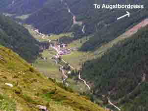
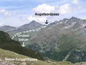
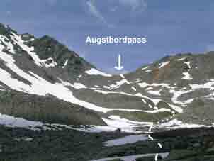
The Augstbordpass - next stage East on the Chamonix-Zermatt Walk
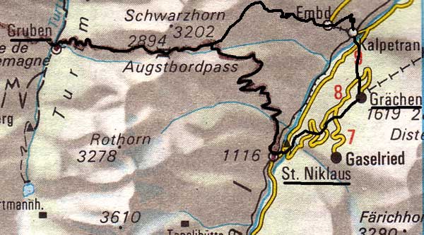 |
This map is copied from the Official Map of the Automobil-Club der Schweiz, (with their permission) which is on this link but not to scale You go up an obvious path to the East of the Hotel Schwarzhorn. This is my diary entry from July 13th 1982:- |
This diary entry is a bit disingenuous. Going up again on July 1st 2007, there is a "Neue Strasse" option near the top of the woods which leads to a jeep track. This does save time for the bit below the hanging valley. Near the top of the valley is a steeper set of zig-zags on rocky ground. This looks like the top but is not. It leads to a moraine path. There is then a track to the top but, if it is under the snow, it is quicker to scramble up the rocks to the right of the obvious pass top. There are traces of a track under these rocks, because they are part of a 'block-gletscher', a rock-fall caused by Global Warming thawing the underlying permafrost.
If you are doing the Chamonix-Zermatt walk, you may have enough oomph left to walk up to Grächen on the footpath which breaks off from the road opposite the station. This is the Grächen walks link & this is the Chamonix-Zermatt walk link.
|
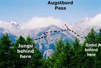
There are, in fact, two options on the East side of the pass... ...after getting down below the July snowfields, 1. There is a signpost for the St Nicklaus option above (lower track on the map). 2. The other goes straight ahead towards Embd & has an up-and-down 'contour' section after crossing the stream. However, there are even better views across to the Mischabel range than on the Jungu option. Eventually, the path drops to Kalpetran in the Mattertal & it is a short walk to Stalden. On the C-Z Walk, take this option if you intend to stay in Stalden & go up to Grächen the next day for a rest day, well earned, before tackling the Europaweg to Zermatt. |
 Augstbordpass West side |
|
 Augstbordpass up the green sward |
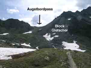
After the steeper bit was (in 2007) a Blockgletscher caused by Global Warming |
The top of the East side: |
The St Nicklaus option (left) & Kalpetran option (right) seen from Grächen. |
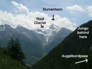
The Durrenhorn, the end of the Mischabel |
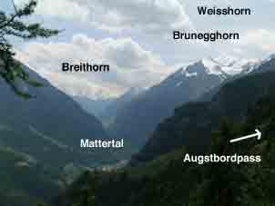 Mattertal looking South to the Zermatt Breithorn. The Europaweg is high up the East (left) side |
Out to the Rhone Valley - the Water tracks
On June 28th 2002. Diary: It was raining so hard that the pass routes were out of the question, so I walked down (North) the Turtmanntal to where the bergweg to "Ergisch bei wasserleitung" is marked. Now, wasserleitung (water track = irrigation ditch) are almost horizontal but the bergweg sign was justified by the precarious position of the track, in some places over very steep precipices & a steady nerve was required. The rain had also made it slippery. I got to Ergisch & had a coffee but the rain persisted, so I walked all the way down the path to Gampel Steg, having unintentionally traversed Bella Tola entirely on foot from & to the Rhone Valley. (I then thumbed lifts to Visp & Stalden & walked up to Grächen for another stage on the Chamonix-Zermatt Walk - the Europaweg).
Contact: Ken Baldry, 17 Gerrard Road, Islington, London N1 8AY +44(0)20 7359 6294 or e-mail him
URL: http://www.art-science.com/Ken/Alpine/Grueben/index.html Last revised 27/5/2012 © 2002-2012 Ken Baldry. All rights reserved.