 |
Ken Baldry's Alpine PagesWalks around Lenk (2) |
This splendid little viewpoint sits between the valley with the Simmen Falls & the one to Iffigalp with the Iffig Falls. The easiest way up it is from the Iffigalp, reached either by bus from Lenk, which is advisable if you intend to walk down the other side of the horn to the Simmen Falls, or a 2 1/2 hour walk, which does take you past the splendid Iffig Falls as well, in which case, you can bus back from the Simmen Falls. I would recommend the 2nd option. You need to walk back for about 8 minutes from the Iffigalp Hotel if bussing it, to an obvious path to a bridge over the stream & then, there is a steadily graded path up past a cow farm to the top of the pass, where the OberLaubhorn path is signposted off to the left.
If you return by the Simmen Falls, you also take in the Siebenbrunnen ('seven streams') fall & beer opportunity. There are photos of this tour on this page.
Take the bus to Iffigenalp, unless you are staying at the Iffigalp Hotel. It is quite an easy & pleasant walk up to the Wildhorn hut. First is a broad path, narrowing & climbing up a moraine. However, when you first see the hut, it appears to be on the forward moraine & when you get there, it is revealed, still to be in the distance on rocks much further back!
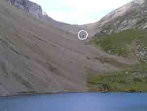
The hut seen misleadingly across the Iffigsee. |
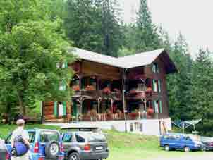
The Iffigalp Hotel |
It took us 3 hours 10 minutes, so a returning walker has time to walk down to Lenk past the Iffigen Falls....
Climbing the Wildhorn 3248m - Alpine option
...or stay in the hut for the night to do the hill the next day. Here is a report of how we did it:-
"There was a general movement to a semi-wakeful condition at 0410 this morning & we struggled into clothes with the usual Everest Camp Six unwillingness. The guardian charged us 11 francs each which was not bad as he obviously makes a flat charge of 2 frs for hot water (1979 prices!). The route lay up the side of the Dungel Glacier snout on steep hard snow.
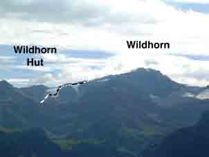
The hut behind the Niesehorn ridge The route goes up the Dungel Glacier, |
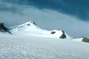
The Wildhorn from the Dungel Gletscher. |
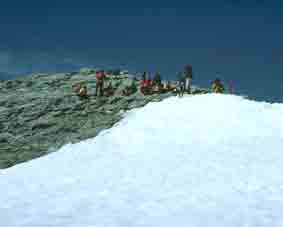
Tactics varied. The Germans cramponed up & the French roped up. We did neither at that stage as it seemed excessive. The Germans seemed a bit nervous & one headed straight up the side of the Chilchli rocks, one of which he dislodged & hit Jane hard on the upper arm she was holding her axe with. She could not dodge as the ground was too steep. The bruise turned out to be enormous & bloody. She cursed him roundly in best English. We traversed over to a lump of protruding moraine & put crampons on as Jane could no longer cut steps. The others all got well ahead. We crossed the Dungel Gletscher & could see the Alsatians go the wrong way. They gave themselves a harder time of it. We made the S shaped move up onto the Glacier de Tenehet (in Valais) from the Dungel Gletscher & up it a long way to the summit. The others all united as they wanted to take an International Photo for their local paper - four nations on the summit (see below middle). The German was very apologetic to Jane about the rock & tried to make up by pointing out the fells. Jane put him down by pointing out the ones we had done. It took us 4 hours to get up but given our accident & heavy rucksacks, that was not surprising. We went back by a different route. All the way down the Tenehet Glacier (keep left!) to the Tenehet tarn. Route finding was now quite difficult off the glacier despite perfect weather because of the thick snow cover. We had had a lovely cloud sea on the way up. The Swiss guys had skied off from the top with quite a display of skill. From the partly frozen tarn, the path nominally goes down to Lourantse on the Rawil path but it is very hard to find & badly eroded. It was very exhausting & the last bit down steep slate scree, quite killing, to the Tseuzier Dam café, where we devoured hard-earned huge steaks.
The Wildhorn Summit is rock. Photo 1979 |
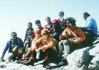
This appeared in the German press |
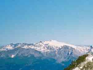
South side (from Bella Tola). Photo 2002 |
Referring to the righthand photo, you come over the skyline snow ridge about halfway up. We went back on this side, carrying on down to the steep bit far right & scrambled down that to Lourantse.
Contact: Ken Baldry, 17 Gerrard Road, Islington, London N1 8AY +44(0)20 7359 6294 but best to e-mail him URL: http://www.art-science.com/Ken/Alpine/Lenk/L2.html
Last revised 27/6/2008 © 2001-2008 Ken baldry. All rights reserved.