 |
Ken Baldry's Alpine PagesChamonix to Zermatt - Day Eight - Arolla to Grimentz |
 |
From Arolla to Grimentz - the Col de TorrentSunday 27th June 2004 I stuffed myself at breakfast, which was just as well, as it turned out. The bill for everything for two nights at the Hotel du Pigne d'Arolla was sfr248.40, as I chalked all beers, coffees etc up. I left at 0845 by the path through the village, which crosses the road at the Hotel de la Tsa & avoids the road until Satarma. No, you cannot avoid the next bit of road as the map LK50 suggests. I nicknamed this path, the Vladimirka Road. At Le Gouille, a path unmarked on LK50 goes down to join the marked path at St Barthelemy, so no more road. To my surprise, I was in Les Haudères at 1030 & the sign there said 'Grimentz 7 3/4 hours', so I thought, let's go for it. Theoretically, one stays in Le Sage, which is about 25 minutes further on but it seemed pointless. The weather forecast was poor, so I wanted to be over the Col de Torrent as soon after 'lunch' as possible & I was helped by both farmers' water supplies & the sky becoming increasingly overcast, so it was not too hot. I met several parties coming down. One had come over & said it was very snowy on the other side (true but not a problem) & some who had turned back at the pass. This map is copied from the Official Map of the Automobil-Club der Schweiz, |
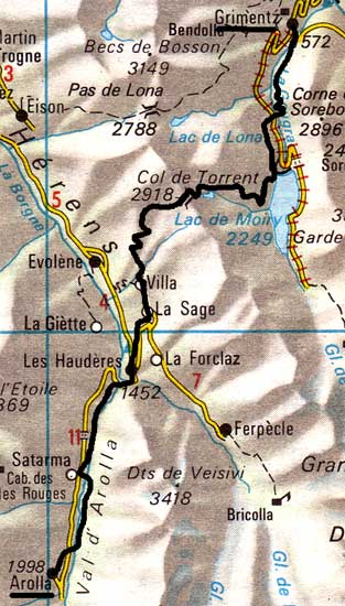
Satarma |
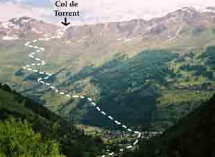
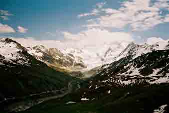
From Les Haudères to the Col de Torrent (under the arrow) |
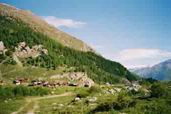
Les Haudères & Dent Blanche |
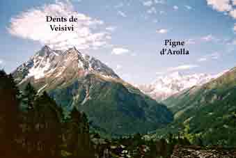
Looking back at the Dents de Veisivi | 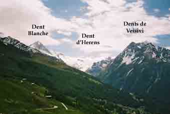
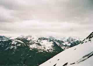
On the way up to the Col de Torrent |
Robbed! The Röstigraben (language frontier) View diminished by cloud |
I was up at 1423 & no threatened thunder but there were vast snowfields on the Moiry side, although where the track should be was easy to discern. The view was not too good, because of the cloud. I stopped at 3 for my emergency rations lunch (2 year old corned beef), as it was clearly going to be a big day. The snow continued for a long way down, especially where the route flattened out but I shipped my ice axe about 250m above where the lake should be, a short distance above the building which is something to do with the water. There was not much water in the lake behind the Moiry Dam, so it was all rather ugly. Indeed, it was almost empty, with the dam showing its pathetic backside. (The Swiss fill their dams up all summer & use the water to generate electricity in the winter). It started to rain when I was nearly there, so I walked across the dam for a beer, successfully but, finding the bunkhouse closed, I walked back over the dam & down to a footpath parallel to & above the road.
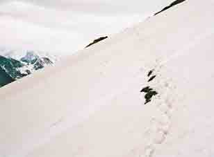
Remember, always take an ice-axe |
The empty Moiry lake & Moiry Glacier |
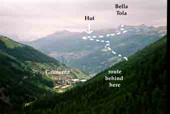
This shows tomorrow's path & the day after's climb of Bella Tola. |
The rain stopped but the bushes (no one uses this path much) soaked my trousers. There are great looping zig-zags to get out of the hanging valley down to Grimentz but the first building encountered was the Hotel Cristal & I booked in gratefully, although the hotel restaurant was closed. It was 6 & I was at least a quarter-hour ahead of schedule, despite crossing the dam & the snow. Laundry, leave message for my wife Avis & bath before food hunting. I had quite forgotten that Grimentz is supposed to be an exceptionally beautiful village! (I have included a few photos on this link). I bumped into an English party of two couples, the blokes being accountants who went to school together & were 57. They had done a fair bit of walking. We all ate in an overpretentious hotel & my share of the bill was sfr50. I had Wiener Schnitzel & banana split.
Contact: Ken Baldry, 17 Gerrard Road, Islington, London N1 8AY +44(0)20 7359 6294 or e-mail him URL: http://www.art-science.com/Ken/Alpine/C-Z/cz8.html Last revised 23/6/2013 ©2004-2013 Ken Baldry. All rights reserved.