 |
Ken Baldry's Alpine PagesRound the Matterhorn. Mauvoisin to Breuil tour - 3 |
Stage Four - The Col de Valcournera from Prarayer to the Rifugio Barmasse above Valtournanche
Feeling better & more inclined for a very hard day, which it is. I had breakfast at 0645 before the others who drifted in. There was plenty of it. I was on the path at 0721 after paying my L50,000 bill. The new bridge is further up the valley than the one marked on LK50. A herd of cows blocked my path & had to be driven on but one soon gets to the path up into the Valcournera itself & some pleasant zig-zags through the woods soon bring one to the derelict chalets at Alpe Valcournera, the beginning of the hanging valley. There is nearly 2km of gentle walk by the river to a place called Chardonney, with nothing there but a painted stone. The Italian way-marking is exemplary, except when it disappears under the snow, for which they cannot be blamed! The hard bit starts ok, if a bit steep but is well zig-zagged. Up at the cliff at about 2480m, there is a ladder with a comfy place to fuel up with mint cake but, after that, the path winds up steeply & not where the map says. (One has to remember that it may be a Swiss map but the info is from the Italian Survey). This comes out on the scree at about 2650m which Chris Wright is so unamoured of & also into the sun. The scree is not too bad to the bottom of the top cwm, where I moved out onto big rocks or snow, because of which, the path disappeared. The pass looked high above ahead. As I could not discern the path, I moved up to the right, as Wright's guide book suggests but clearly too far, as I got onto more & more dangerous scree after comparatively comfortable big rocks. I managed to get onto the rock outcrop to the right, which was safe & moved up to another snowfield, across which I did a rising traverse to the left. As there was nowhere comfortable to unsling my huge rucksack, I used a pointed rock as a stone-age ice axe. This got me to another rock cliff, up which I pulled myself by hand, as the ground was steep powder. Each hold had to be tested, as the rock was quite rotten. After a few metres, I could see the official path in the middle of the gully to my left & could soon traverse safely to it. This was sweet relief & soon took me to the Col at 3086m. The payoff was a fantastic view, over to the Chateau des Dames.
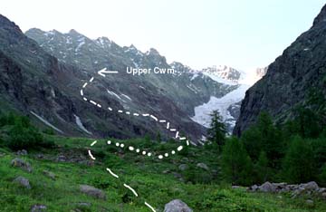
The Valcournera from the Prarayer Hut. |
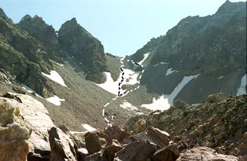
Upper cwm of the Col de Valcournera. |
In fact, the views were constantly changing & always full of interest on this side. There was 10m of disgusting path, which then disappeared under a huge snowfield which also coverd the first lake below. Using my proper ice axe, I backed down for 30m then traversed off to the south, kicking steps for half a km to the currently closed Rif.Perucca e Vuillermoz at 2900m, where I scoffed half a tin of well-earned corned beef. The next bit down was also snowed up but I could ship my axe before getting to the bivouac hut at 2790m & above the Lago Balanselmo, where 4 Italians sunbathed & told me I had big balls after I had said what I had done. I had described myself to the climbers last night as a drip. All relative, I suppose. After the hut, I got the height loss at last, with many unmarked zig zags down a pleasant cliff with a pretty waterfall to the left. This gets you to 2500m & I crossed the stream from the Gran Lago to a very long & mostly dropping traverse towards the Alpe Cignana which killed my remaining energy. I had met various other people on the way. Some did not know the top hut was closed. The path goes down to the Swan Lake (Lago Cignana), which is quite attractive, despite being dammed. Then, I crossed the dam to the Rifugio Barmasse at 2189m. This is run by Mrs Smegma, judging by the number of Rules pinned up but she was actually quite attractive in a late middle aged sort of way. There are no proper washing facilities here & it is L.77,000, which would be quite expensive if the food was not so good - spaghetti, salad, a sort of offal stew, fruit & a big slice of cake. I had a dormitory to myself again. This slog took 8.5 hours.
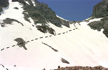
Col de Valcournera from the East |
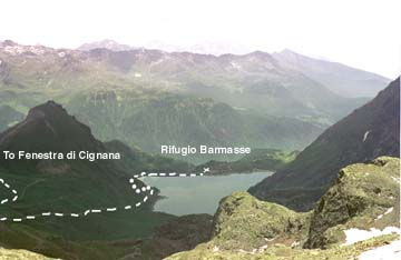
Lago di Cignana. Stage Five path on left to the Fenestra. |
Contact: Ken Baldry, 17 Gerrard Road, Islington, London N1 8AY +44(0)20 7359 6294 or e-mail him URL: http://www.art-science.com/Ken/Alpine/RM/RM3.html
Last revised 29/3/2004 © 1998-2004 Ken Baldry. All rights reserved.